Showing posts with label icehouse canyon. Show all posts

Monday, May 6

Ontario & Big Horn Peaks Overnight - San Gabriel Mts

"All you're doing is reading a book with your feet."

 photo DSC_0028_zps9c36665f.jpg
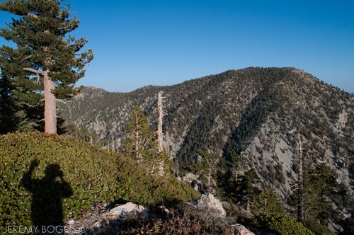
| Hello from above 8,000ft |

I heard the above sound-byte on This American Life (NPR) the other day, spoken by a man of wise age to a twenty three year old kid that was undertaking a walk across America & it was just a nice sentiment to mule over while walking down the trail.


| Click To Play |
 
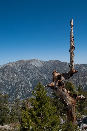
Many that are familiar with Icehouse Canyon know the stampede of cars on the weekend that bombard the parking lot & the almost constant flow of hiking enthusiasts & newbies walking the trail to Icehouse Saddle. Understandably a popular trail due it's wonderful beauty & it's mild grade for much of the first couple miles, with a good hearty switchback section to get the sweat going. Named for it's early history of Ice production & ability to hold snow longer than other areas of the Gabriels.
 
 photo IMG_0965_zps39a02bb7.jpg
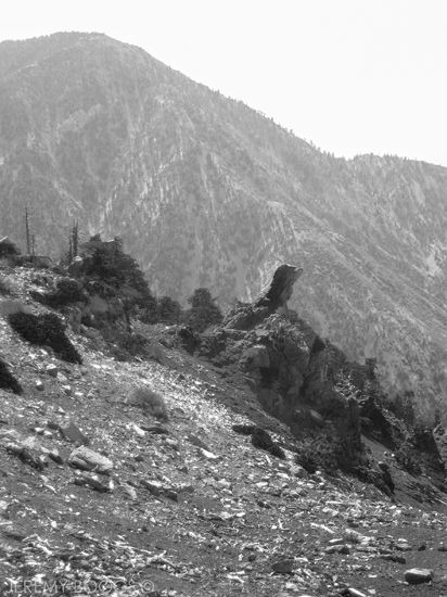
| Several section's still with snow at Kelly's & on the way |

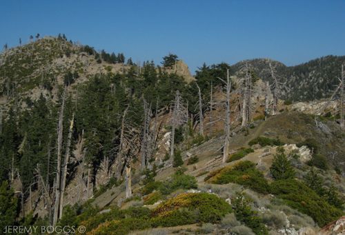
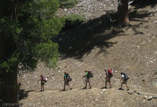
A good portion of hikers end their day at the Saddle & return to their cars, but this is a 5 way trail junction over 6,000ft, there most certainly is much more to explore. In the past we have gone over the Three T's from this point which is a stunning hike of total seclusion & also another time on a solo trip to Kelly's Camp

 photo IMG_0968_zpsf5c372d7.jpg
| How could anyone sit on the couch? |

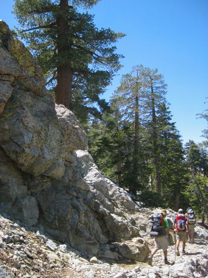
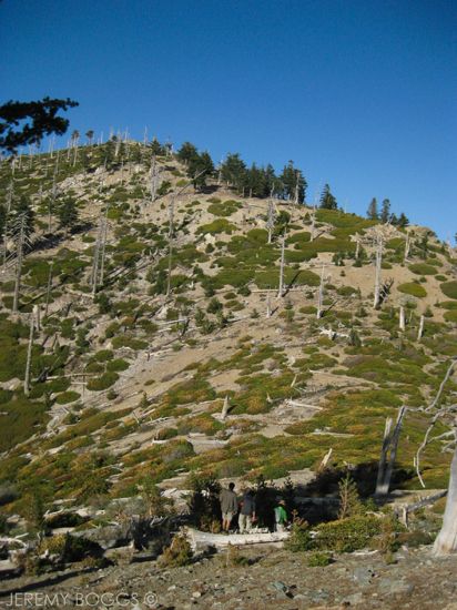
Our goal this time was to bag Ontario & Big Horn Peaks, so off our group went towards Kelly's Camp (well marked). This next mile or so to the camp is such a stunning section of trail. It slowly brings us south on the flanks of Big Horn & in plain view of Mt. Baldy across San Antonio Canyon. There are amazing rock formations standing thirty feet over head at times, layered in brightly colored lichen.

  photo IMG_0976_zps2f931447.jpg
| Ridge trail to Big Horn Peak (on left). Can you see three hikers? |

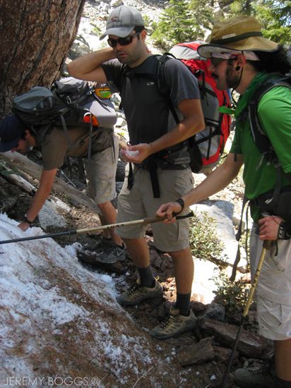
Along the trail up to the saddle we passed two different boy scout troops eating lunch, we learned they two would eventually be heading to the same camp. A crowded nights sleep was our main motivation to make it to camp fast. Perched high above the camp floor, we set up for the night's stay with no one around. 

 photo IMG_0978_zpsd96345ac.jpg
| Final climb to Big Horn's summit |

 After filtering water & making a few new friends we decided to check off one of these peaks. The trail out of Kelly's Camp climbs nicely to a beautiful saddle (un-named?) with a sign pointing in both directions, one for Ontario & the other for Big Horn. We opted for Big Horn & set out on the gorgeous ridge trail that lay before us.

 photo DSC_0031_zps6e7a6ba7.jpg
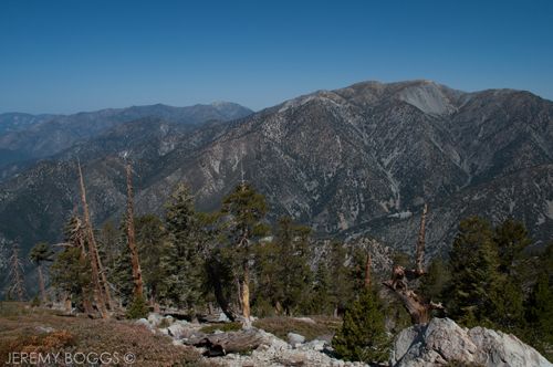
| Left to Right: West Baldy, Mt. Baldy, Mt Harwood, Telegraph Peak  |

Wrapping around a few roller coaster bumps, we found ourselves looking right up at the peak, only about 5 more minutes of some steep uphill. The sun was beginning is descent in the Western sky behind us, setting up for a magical summit experience.
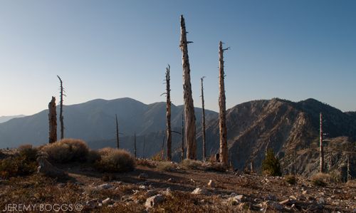
 photo DSC_0041_zps0d9315d8.jpg
| Big Horn Summit |

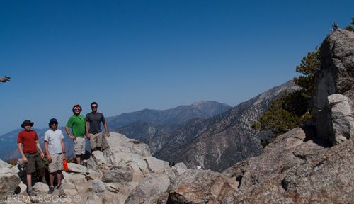
Resting easy at 8,441ft on Big Horn, the four of us looked off towards Cucamonga & Etiwanda Peaks, growing majestic with the waning light, pondering further travels soon to come. Wrapping up with a group photo we set off for camp, deciding for a cross country route that proved to work out well. Arriving just in time to meet our friends Bud & Krista that had just walked into camp, happy to drop their packs & relax.

 photo IMG_0991_zps1de98e20.jpg
| Trail leading out to Ontario Peak |

Now our group was complete with all six & what would become infamous as our most bountiful backcountry meal to date could commences. Still baffling to us, the shared dinner meals just kept coming for close to two and half hours. Everything from crispped brussel sprouts to teriakyi chicken salami burritos.

 photo IMG_0995_zps42535df0.jpg
| Rock formations & Cucamonga Peak in the back |

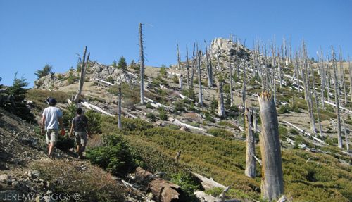
The next morning, four of us set out to tackle 8,693ft Ontario Peak. Marching once again to the first saddle with the wooden sign pointing 1 mile to the peak. But others have scratched in another .7 to add to that mile. Does anyone know if this is true?

 photo DSC_0056_zps27d71532.jpg
| Looking south from below Ontario Peak |

From the saddle the views of the entire Baldy/Telegraph region only grow each bend in the trail. We slowly gain ground to a great false summit, at which point you can actually see the real summit off in the distance. All that means is more stupendous ridge walking. At times the trail follows close to very exposed edges (with no danger) that gave us such wonderful show in all directions.

 photo DSC_0064_zpsfc08641d.jpg
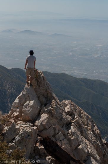
| On top of Ontario Peak, looking north (& a hint west) |

Reaching Ontario Peak was a great feeling. Riding the high of mother nature's bounty laid out before us was exhilarating on this peak. We could see Mt. Baden-Powell far off in the north west & our recent nemisous, Iron Mountain, standing rock solid & "unassuming" from this vantage... but we know better now. My thoughts wandered to the PCT hikers that were slowly making their way into the Jacinto, Bernadino & Gabriel ranges now & what a wonderful life changing struggle that would be to accomplish.

 photo DSC_0054_zps2e62695a.jpg
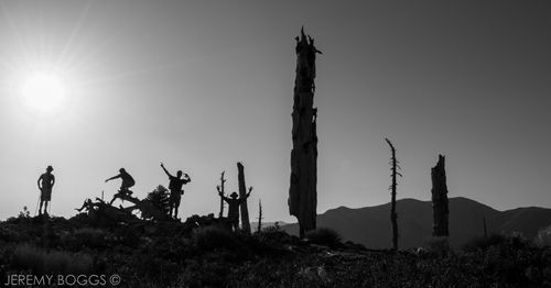
| Timed photo: Ontario Peak |

Still snapping pictures away & trading stories with other hikers that have now summited, the views only unfold more as we take our time to really drink them in. Telegraph Peak has got to be one of my favorites in the entire Gabriels. While observing it from any far off trail it's craggy chutes & elusive deep summit are such a wonder. The views from atop (& the entire Three T's hike in general) are out this world.

 photo DSC_0069_zpsc4ec4244.jpg

Back at camp we knew it was time to throw on our packs & make our way back down Icehouse Canyon to our cars. Our trip had been a success on many levels, even helping out several hikers that didn't quite know what they were getting into setting out into the CucamongaWilderness. With all experienced hikers it is amazing what you can accomplish; a comfortable excursion into the upper elevations of our local world can be such a welcomed escape from city life. On our exit we managed to hike the 4.6 miles back down canyon in one hour and fifty minutes. Felt damn good.

 photo IMG_1007_zps397a2732.jpg

Till Next Time.

Wednesday, October 10

Three T's Backpacking Trip - San Gabriel Mts


Pulling up to the Icehouse Canyon parking lot, we could tell we were late for class... Packed to the brim & beyond with cars. Not uncommon though, especially if you've ever been to Chantry on the weekend. Hoisting our packs, we did some road walking to get to the trailhead & set off in high spirits towards Icehouse Saddle. Our goal for this "boys" trip was to try a new trail (to us) that qualified as a more strenuous hike, as well as call our own shots for where to camp, a bit more "thru-hiking" style. The Three T's Trail will take us to three different mountain peaks that all begin with the letter T... and they all require to go down before up.

| Hiking up Icehouse Canyon |

Heading up Icehouse is such a picturesque canyon at times (other times over used), dotted with cabins from the 1920s along the first couple miles. The name derives from early Los Angelenos using the canyon to produce ice, the positioning allows for the snow to last long in this area. After a couple miles & a 1,000 feet up, we came to Columbine Spring, flowing straight out of the mountain, this was out time to fill up b/c there would be no water till tomorrow when we finished our hike. We were only 2 miles in to 10 miles our trip was looking to be. Hoisting our packs once again, the weight of roughly 6 liters was very apparent.


The spring is also conveniently located at the beginning of the steepest part of the trail. So, up & up we went, covering 2,260 ft of elevation gain, to the saddle (3.6 miles). Affording a nice break & a chat with many different hikers that always tend to congregate at Icehouse Saddle (if we were still using the high school analogy from the beginning, the saddle = the cool kids lunch spot). Lots of people wanted to know where were going & would follow with, "are you staying our here tonight?!"

| Looking down Icehouse Canyon |

Collecting our things, hoisting our packs & getting a traditional trail group photo, we moved on towards our first peak, Timber Mountain. The crowds thinned out as we headed along the sides, switch-backing up, slowly gain grander views of the canyon we just hike through. Topping out on a western flank of Timber, we spotted a spur trail that was a half mile round trip to the summit. Dropping our packs, Collin man-ed up & carried his in case of good camping, we climbed to the summit of Timber Mt.

| Carlos on Timber Summit - 8,303ft |

Getting a chance to scout tomorrow's route & also evaluating if we should press on to find camp or stay on the flank near the spur trail junction. Opting to stay put & camp on the rounded flank of Timber Mt, sort of near the spur trail junction.

| Camping looking out towards Telegraph Wash |

This post seems to be getting lengthy already and the sun hasn't even set on the first day... I would say the photographs & the video will do the evening justice. The views were spectacular all around, there was nice shelter from the wind & a beautiful morning to wake up to the next day. 


Packed our gear, took some photos, ate a hearty breakfast & we were off towards our next peak. The trail down to the saddle after Timber was easy as could be without a single other person in sight. However, we were constantly reminded of the test that lay before us, the trail continuing up to Telegraph Peak.

| Collin & Carlos looking to the West |
Beginning a bit tough & through some overgrown shrubs, the trail climbs quick, slowly becoming a better graded adventure after a mile or so. Part way through our uphill climb I wished I had began to count to switchbacks going up this darn mountain! Alas, I didnt even heed my own advice b/c if I had begun counting even half way through the trip it still would have amounted to over 20 I imagine, only part way up... maybe closer to 35 total? Below is a picture of the task ahead, Telegraph Peak being the furthest in the back right.

 
| Telegraph Peak, back right |

The wind was a constant companion that breathed new life into us as we snaked up the mountain, popping out at time to get craggy views of Telegraph Wash. Finding another spur trail with a round trip of a half mile to the actual peak... the standard ensued, drop packs & hustle to bag another peak. Quite easily one of the best summits I have stood on in the San Gabriels. One could count more than ten peaks in the area that are all glowing in monumental triumph. Before leaving our roost on Telegraph, we scouted our route to the next peak, opting to try & climb straight from the next saddle up to Thunder Peak. Normally the trail takes a nice loop around the whole summit & doesnt actually touch the peak.

| Looking towards Bighhorn Peak & Coucamonga Peak. Do you see Collin? |

Signing into the Telegraph Peak register, we hustled back, hoisted our packs & set off down hill towards the next peak, with two in the bag. At this point we crossed our first people since the day before, coming from the Baldy Lodge direction. This portion of the trail is really well graded and a nice hike in either direction. 

 
| On Telegraph Peak - Lt to Rt: West Baldy, San Antonio Mt, Mt Harwood, Pine Mt |

Arriving at the saddle, Telegraph Peak looked to be a behemoth of a summit from here, but nothing compared to the way we came from. The wind howled in the confluence of the canyon, cooling all of us to the core. 

| Mt. Baldy early morning |

Sticking to the off trail climb, we made our way slowly, designing our own switch back pattern up the backside of Timber Mountain. After a few good rests & some steep walking, we arrived at the ski boundary 50 yards shy of the summit we were aiming for. A good timed photo of Collin, Carlos, and I bagging our third peak for the trip!

| Hiking up to Telegraph from Timber Mt |

We have now crossed into the Baldy region of the San Gabriels. In the winter it becomes a ski resort & our goal was to walk the dry ski runs down to the lodge that operates on the weekend for hikers. Doesn't sound too challenging right? Well, not the case. Day hiking isn't too bad, but after two days, three summits & over-night gear on your back, the rock strew wide open gulleys are a twisted ankle waiting to happen every step. With toes cramping from the downhill we strolled into the Baldy Lodge ready for a burger & a beer.

| Down the rock strew ski runs w/ Baldy Lodge in sight |

After feasting, we had two more goals, to take the chair lift down to the parking lot & somehow avoid the many miles of road walking we had to do to get back to our car at the Icehouse Canyon trail head. Fortunately there were many others finishing their day hikes & heading back down the mountain, after a friendly chat with a young newly wed couple, I cracked the question to see if they could take 3 smelly guys down to our car? They were much obliged & we learned they were new to hiking in general & had managed to get a coupon to the "ski lift & lunch" that took them to some of the best views they'd seen! Great times all around in the outdoors.


Is this the last backpacking trip of the year?!?! It's getting kind of chilly.... we'll see.

Sunday, July 8

Kelly's Camp Solo Backpacking Trip


Took off for a one night solo backpack trip to see a camp I had never been to yet, Kelly's Camp under Bighorn Peak. Looking forward to some solitude midweek. Kelly's camp is a high altitude camp from the 1920's that had several structures which strong willed city dwellers could hike to, but enjoy a "some-what" modern dwelling. 

| Video of my trip, click the play button |

All that is left today are a a few foundations & the imagination that this open corner in the woods has been enjoyed by thousands over the years.


I have done a portion of this trail up to Icehouse Saddle, but not the final push off to this portion of the mountains towards Ontario Peak. Trying to keep my pack weight down for a one person trip I managed 28 lbs with food and all. Knowing there would be water I opted to carry minimal water and filter along the way at the few springs. Trying to hike smarter, not harder.


After the almost 2700ft, 4 miles uphill climb to Icehouse Saddle I was sweating up a storm. After a break I took one of the 4 trails leading out from the saddle towards Ontario Peak. This was the new portion & it sure was stunning. The views of Baldy are well worth the extra .25 you could walk on this trail to get out of the trees.


Met a good man named Casear that worked for the Duarte Parks Dept and his son, Sean, out enjoying the woods for the night as well. Being the only gents in the woods that night, it was welcome to chat every so often.


The bugs during the day looked pretty bad, but the cool temps of the night & the 8,000+ elevation helped them subside. Morning sun had not crested before I opened my eyes, laying there deciding on if I should hike to the ridge for sunrise.


Around 4:55am I made the choice to get out of my sleeping bag and start getting ready to hike in the dark to the ridge. After a steep, dark, enjoyable hike I came upon a site that was well worth getting my butt out of bed.

| Since this trip, I returned the GSI Dualist & opted for a Snow Peak Titanium Solo Kit. Dropped almost two pounds |

After spending some time shooting video & photos, Caesar and his son showed up to enjoy the site of the clear sunrise towards the desert, with Los Angeles covered in a sea of clouds. In hindsight, I should had breakfast before heading out, I could then have pushed to one of the two summits.


All in all it was a great trip in the woods. Seeing some new areas of the forest & getting to know a bit more about myself in the process.

Tuesday, March 6

Icehouse Canyon - Backpack Training

| CLICK ANY PHOTO TO ENLARGE |
The gusts of wind came continually down the canyon with an icy freshness that both invigorated me & had me in total wonder of the new region of the San Gabriels I was exploring. Icehouse Canyon had been living up to it's name without question.

| Backpack Training Mt. Baldy in background |

 A local favorite among pretty much ever hiking book & website, I figured it was my time to give it a try. Short history of the canyon, in the 20's it was a major ice production area due to it's location, along with timber cutting pulled by oxen from upper reaches of the side canyons. I was in awe that anyone made this possible.


 This trip was the beginning of endurance building for longer backpacking trips planned over the next few months. Carrying a fair amount of weight up the 2,700 ft of elevation change & 4 miles of trail was an excellent first test back. The rock strew trail winded up to a mountain spring that I missed on my way up, but thoroughly enjoyed on my way down (video w/ new sterilization techniques to come).


While part way up the trail I passed into the Cucamonga Wilderness, a sub-alpine protected area little over 12,000 sq. ft. The snow was plentiful & pristine all along the north facing ridges. One could even make out animals tracks coming down from the denser upper forests to the creek side.

| Lunch off the ridge below Timber Peak |
 
 At the top my body had eaten through all the energy my breakfast had provided & was ready for a remote lunch. I spent close to 2 hours reading, shooting photos, & randomly sending the most remote text message I have had the chance to. The above photo shows base camp, looking out into the Cucamonga Wilderness.

| Natural Icebox at 7800 ft |

Another great thing I found out over the day about this trail was it was the more adult cousin to Chantry Flats area. Though somewhat populated, I found that all the hikers seemed to be in training mode, trail camping or out for the features of the snow country. No families, no teens, no trash, and almost no graffiti. Hiking solo on this journey allowed for me to stop and talk to almost 15 different people. Some eventually heading all the way to the Grand Canyon & Yellowstone. However, later in the day on my way down the trail, it was strew ever so often with late afternoon families enjoying the lower creek area.

| Switchback on Icehouse Canyon Trail w Mt. Baldy in background |

The upper reaches of this canyon allow for almost six different routes & I only made it a bit above the 7,555 saddle. This allows for more adventures down the road. Along with great beauty, one of the funniest wilderness moments happened while I was having lunch looking out into the hills, ponder something profound, a deep voice called from miles across the canyon, "Vote for Donnelly!" I laughed, replied the same, & never stopped smiling the rest of the day.

| Video of the Days Adventures - Two minutes |