Saturday, May 9

Not Retired. Just moved.

Been a while. Haven't stopped adventures, haven't stopped moving forward. However, there are better places to see all these things now. Below are locations I am updating a bit more frequently with our outdoor exploits.

Instagram: adventurela
Website: jeremyboggs.com
TRVRS Outdoors: trvrsoutdoors.com
Youtube: Boggs12345

Here's a glimpse of what has been going on. Last adventure before COVID took hold of the West Coast.

Friday, December 8

Gene Marshall Piedra Blanca National Recreation Trail - Los Padres Natl Forest


A much lesser know trail is tucked away deep in the eastern Los Padres National Forest that gives hikers a truly dynamic hiking experience. Low lying chaparral zones, Native American pictographs, tall pines forest in alpine zones & what appears to be heavy bear habitat in rolling canyons. Since the 2017/2018 Thomas Fire, one of California's largest in history, this trail has been closed, so double check before you go.


I had been trying to get a trip together to hike the entire 19-ish mile length of the Gene Marshall Piedra Blanca National Recreation Trail for some time now. There are some logistics that make the set up a bit cumbersome, but not outrageous. The car shuttle is the worst of them. Connecting the Reyes Creek Trailhead and the very popular Piedra Blanca Trailhead is about an hour drive between them, both several hours from Los Angeles proper. Another factor to consider are portions of the trail can reach elevations that will get snow in the winter & the water situation can be tricky in certain seasons. Check here for updated water reports


Now to the hiking. We chose to leave the first car at Reyes Creek and then drive around to Piedra Blanca trailhead. This meant one big climb mid hike on day one, with lots of rolling downhill terrain on day two. Leaving the cars behind now, turning left at the trail sign that points MOST everyone to Willet & Sespe hot springs felt good to finally get on portion of this trail I hadn't hiked before. 


Weaving through the large sandstone monoliths that can be seen from all around we kept a sharp eye for the famous pictographs that are quite accessible from what I had read previously. We lost our way a bit and missed finding these, but got to do some fun scrambling all over the boulders. Back on the trail, we headed east towards the huge cliffs that make up Pine Mountain. 


Along the trail we found a lot more water than expected in Piedra Blanca creek, passing the first two camps, Twin Forks & Piedra Blanca, ideal for those wishing for a short overnight. Getting further now into the North Fork towering canyon walls began to rise up, giving a very dramatic look. 


Rambling left and right, crossing over the river a few times we finally were at the base of our climb to the mountain pass that guarded a much anticipated pine forest. Couple miles with 2,000ft of gain were ahead of us, but we took it mellow & were on top within no time. Moments were quite steep, but steady for the most part. Best to do later in the day b/c the western ridge shaded us from the hot sun.


Now at the apex of our elevation gain for the trip we wandered around following the path looking for our camp. We had decided to use Pine Mountain Lodge Camp b/c it seemed to have the most reliable water source of all the camps. We would learn the next day a few of the camps further on the trail also had access to a bit of water. It was early December and not a time know for burgeoning creeks. 


After setting up our essentials we headed out of camp on an easy use trail for about five minutes to find the water source. Flowing, cold & serene. Upon returning to camp we had a visitor. First person we had seen since the parking lot that morning. A woman was there and proceeded to explain she had slipped and broken her wrist not more than forty minutes ago on trail?! Still quite calm, her wrist was very swollen & wouldn't move. We helped her fashion a sling, get a warmer layer on & move food from inside her pack to the front. It was 4:30pm and would be dark very soon. She had about seven miles back to her car & explained last time she was out in this area she got lost. A bit concerned we double checked the map with her to make certain she knew the direction she needed to go & all the little details of the route. Off she went and we just hoped all was going to be ok. Full disclosure, we found a Facebook post after our hike that she had safely gotten to her car & to a hospital around 2am. Good to know after the fact.


Back to our evening at Pine Mountain Lodge Camp, nothing out of the ordinary the rest of the night, but that was the only person we would see the entire trip. Just the way we like it next to the metropolis that is Los Angeles.

----------------------------------------------------------------

The next morning we slowly packed camp and set out for the remaining 11 miles or so we had to reach the Reyes Creek trailhead. The scenery all along these first miles was some of the best of the entire trip. Canyons, pines & peaks were all around. We'd reach these low saddles that afforded wonderful views, then dropped down into lightly used canyons. 


Reaching Three Mile Camp we found water again, but it was frozen over! This would have been a very cold night if we had continued down to this location for sleep. Still continuing downhill for the most part, now through heavy burn areas. All these miles & the next portion were the most signs of bear I have ever seen in Southern California. Scat, claw marks, paw prints & fur at one point all gave proof we were not the only ones to be using this trail. 


One of the only two confusing parts of the trail was near Haddock Camp. Our trail bends around a knoll, while a peak trail crosses the creek and leads up the mountain side. Make sure you are on the right trail at this point. 


Still more downhill with punctuated climbs brought us to more saddles with outstanding views. Taking breaks from time to time just to sit in the quite beauty of this seldom traveled place was a great reward.


Finally down much lower our trail was in a new canyon that revealed an even greater bear presence. At times more sandstone walls rose high above, begging to be explored. Fall foliage littered the ground thickly while we strolled among barren forest. We took our last break at Beartrap Camp, very ideal for a quick weekend get away with water close by and just far enough from the car it takes a bit of effort to get there. 


Once leaving Bearcamp there is a water crossing that brings one to switchbacks that are seen on the map, but for some reason hard to locate the beginning of them in person. We had separated a bit and all three of us had trouble starting the climb, but once on the trail VERY easy to follow. Cresting a fairly large hill, massive pine forests climbed the mountains to the west of use, while the high desert can be seen way in the distance.


 Joining my companions again miles later at the last trail camp (Upper Reyes), we made the last ascent to a saddle & all cruised the last few miles to the trailhead. It felt great to finally see this slice of the Los Padres after so many other trips in the lowland chaparral that this National Forest is so infamous for. I highly recommend this trip once the forest service opens it up again.


Friday, September 15

North Lake to Pine Creek via Piute, Puppet & Royce Pass - Eastern Sierra Mts


| Piute Pass center back |

Californians have it good. Without question. The weather, the land, the access to adventure is endless. Don't get me wrong, every state has it's amazing beauty, but the Range of Light, the Big Sur coast, the crags in Death Valley & up to the dense old growth forests of NorCal... seriously all here to explore. Let's see what's beyond the trail.


For sometime now I wanted to take my backpacking skills to the next level & plan a short multi-day trip that would take some confident friends off trail to unique places in the Sierra we had only looked at before. Spending a few weeks of research, I had put together a combo of options that untimely led us to a fine little route above & below treeline for a few days.


Parking at the North Lake Piute Pass trailhead we had a solid group that would slowly diminish over the following days due to city obligations. Ultimately three would be left to finish out the last days. 

| Rough outline of what we did |

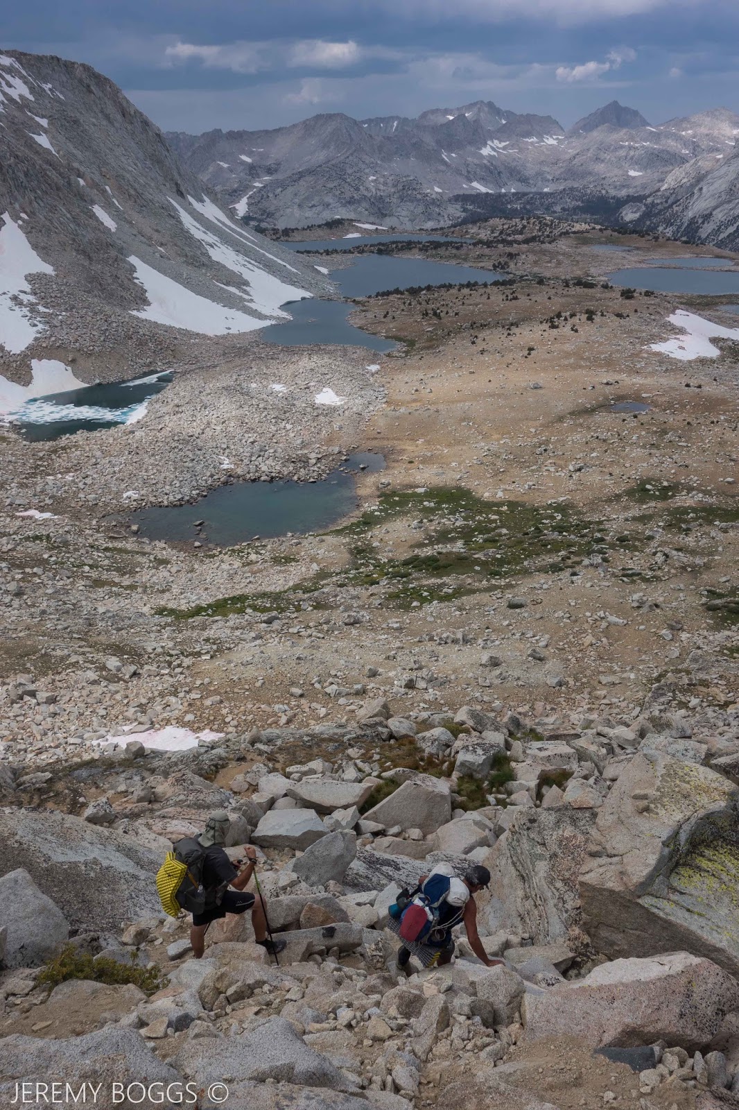
Off we all went up to the first pass on trail. Gorgeous, steady & never truly grueling we all topped out with earned insane views into Humphrey's Basin by mid afternoon. The trail took us down to an exposed but sizable horse camp below the pass.

| Over the pass |


| Part of Humphrey's Basin |


The next morning two friends had to get back to the city so they hopped back over Piute Pass while the rest of us set out to find Desolation Lake. Missing the obvious spur trail that everyone else seemed to write about was not really a problem, we just wandered around upstream till be found the outlet leading the right way. Another hour of hiking brought us to the massive & barren Desolation Lake.


| Lower Desolation Lake |


At this point two more members were going to spend the night here & then take two days heading back out the way we entered the Sierra. Gorgeous & expansive were the surrounds while we all snacked together.

| Glacier Divide |


| Mt. Humphrey - 13,151ft |

The last three of us that were to continue on were eyeballing Puppet Pass/Carol Col in the distance that seemed to be holding some snow in places. It was early September & last winters snow still held in places. Roper & Secor have great descriptions of this area & are pretty spot on for approach ideas. Another extremely valuable resource is High Sierra Topix.

| Puppet Pass. Just on the right shoulder |

| Down Puppet Pass - Roget, Blanc & Lorraine Lake |

We picked our way through the inclined slabs that make up much of the Sierra above tree line. With a keen eye these natural ramps can take a hiker almost anywhere they want in the mountains here. Topping out we strolled to the shoulder of an unnamed granite spire on the cusp of our next massive basin. Hunting across the top of the off trail pass we never did find the plaque that commemorate someone named Carol that unfortunately passed away up here, but we did find the jump off point to scramble down into the basin. Never too difficult with care, this was perfect class three terrain between 11 & 12 thousand feet.

| Pilot Knob - 12,245ft |

| Looking at French Canyon, Pine Creek Pass & beyond |


| Moon Lake. Merrian & Royce Peak in distance |

Views stretched for miles & miles in all directions. We could see across French Canyon to the Royce Lakes area we were aiming for tomorrow morning. An absolutely massive waterfall was spilling over the cliffs that only amplified the beauty. Still hiking off trail we picked our way through snow fields, passed cliff bands & down to Moon Lake. This was our original goal for camp, but it was still only two in the afternoon. After a decent rest we shouldered our packs & set off to find the main trail down in French Canyon. 


| Four Gables Sunset |


Back lower in the trees & on trail, we put a little dent into the morning's miles before resting. After browsing the possible camp sites all along the trail in the canyon, we settled on a knoll overlooking much of the upper peaks. A small rain patch blew over, but didn't soak us much. 


| Alpine - Merrian & Royce Peak |

The next morning we had trail uphill for an hour or so up until we reached the tarn at Pine Creek Pass. From here we set off for the next off trail section up towards the alpine environs. Without much trouble a steady climb was had away from the pass & along perfect green tundra. Giving way to a moonscape of stunning beauty. 


Taking shelter behind whatever boulders were the largest, we admired the grandeur of it all. Merrian & Royce Peak (13,253ft) right above us. Pushing further towards lake 11,725 a large boulder scramble ensued along the southern shore. It wasn't terribly hard, just careful movements. 


| Kevin with Feather Peak |


| Lake 11,725 |


Our objective was to round the entire lake & use Granite Park Pass to move into the next drainage. More boulders, boulders, boulders. Then a disheartening sight. Quite a bit of snow was still hanging around in the path of our approach. Kevin even gave it a good look from above, seen in a photo below. We sat for a snack & talked options. Without foot traction devices or snow tools it would be sketchy at best, without knowing what the decent looks like as well. 


| Other side Lake 11,725 |

| Granite Park Pass left of center with snow in gully.
Kevin is tiny in the very upper right checking out
 the rest of the snow & angle (click to enlarge). On the other 
side is a thousand foot descent that we can't see too. |


We opted to back track thirty minutes or so & access Royce Pass. This would take us down into a different canyon, but ultimately leading in the direction we needed to go the next day. Though maybe not the technical thrill that Granite Park was going to be, Royce Pass made up for in sheer beauty. An easy hike off trail down waterfall laden shelves of granite were ideal after all the large boulder tramping above.


| Royce Pass looking into Pine Creek |


| Looking back up at Royce Pass |

After an hour or so of this terrain. we veered off to find Golden Lake for our last night out in the Eastern Sierra. We all grabbed a super gold dip into the lake & enjoyed whiskey topped off with a golden sunset garnish.


| Golden Lake |


Packing our bags for the last morning, a 3,000 foot decent into Pink Creek was needed to find the car. We spent about a hour off trail in the trees & along the slabs, eventually crossing the main trail down the canyon. Cruising now, lake after lake passed by with views to the high places we had been days before. 


| Honeymoon Lake. Royce Pass left of center |


Knowing now, Pine Creek would be a tough hike uphill, but down was a steady push with cool sights. Larges cascades at times roared just below. Opening up to beautifully blasted switchbacks lower down. Also treated my historical nerd side seeing an early 1900's era mining operation. Crazy to envision the multi-tiered ore tunnels dug high on these cliffs at the Brownstone Mine.


| Look close, multi-tiered shafts |


Landing finally in the dirt parking lot at the Pine Creek trailhead we all felt really great about our first off trail romp in the Sierra. Till next summer season, the maps will be out & helping envision future wonderful trip outdoors.