Sunday, December 23

In Search of Tom Lucas Trail Camp

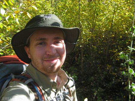
Shouldering our packs amidst the 1920's cabins that line the entrance to Gold Creek, our imaginations can't help but wander of the lucky few who own these stunning retreats strewn throughout the Gabriels. 
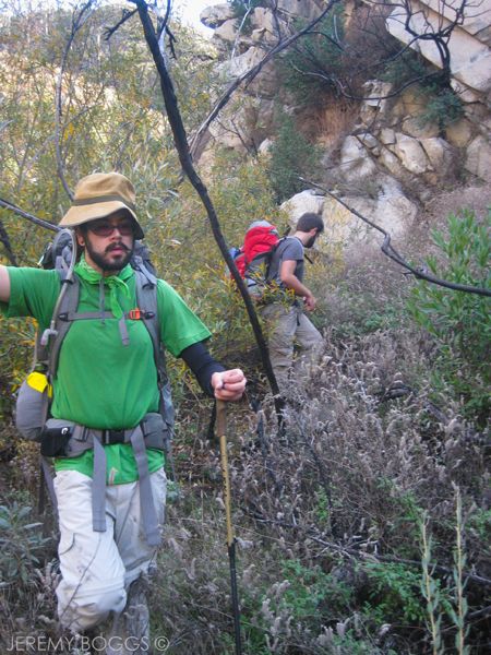
Collin, Carlos, & I are set for an overnight in a region we haven't visited & with a possibility of all types of weather. Following the path in search of a true San Gabriel pioneer, Barefoot Tom. An early grizzly bear hunter & one of the very first forest rangers for the Angeles National Forest.

Photobucket

A standard brown forest service sign at the beginning warns this is not a maintained trail & has not been for some time. The whole are was burnt over in 1975 by the Big Santa Anita Fire, but has made an amazing come back that we will soon be punished by. Many trees still line the canyon floor completely bare, but standing.


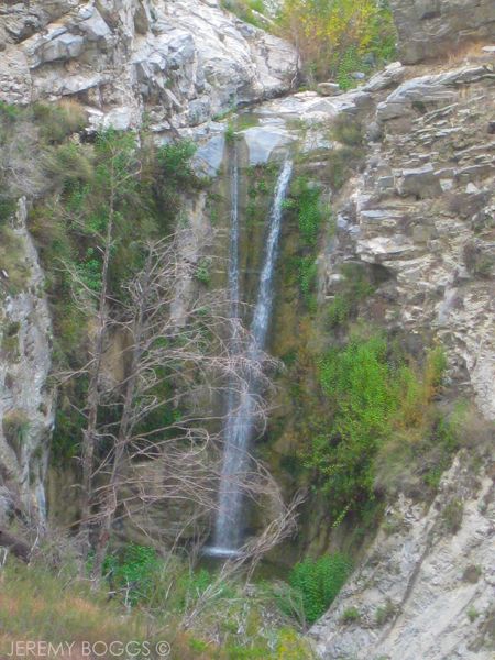
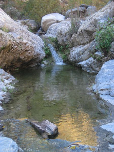
The first portion of the hike to Trail Canyon Falls is quite easy going & nice. I'm certain that if more weekend LA hikers knew of this waterfall it would be over run similar to Stuervant Falls on a weekend. A graceful whisping wall of water is rolling between a huge cut of boulders, plunging through green ferns lining its steep walls.

Photobucket
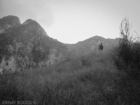
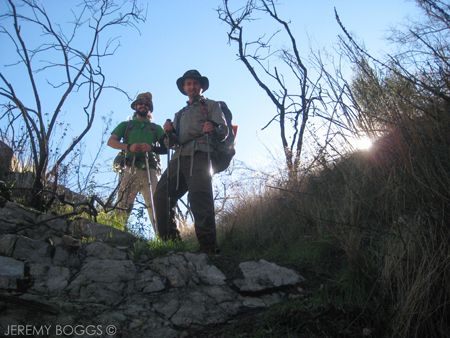
| Can you see Collin hiking? Left of center |
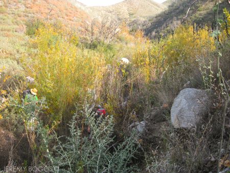
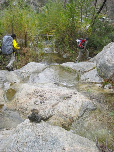
Once we had past the falls the trail easily falls into the "unmaintained" category. We begin more of a boulder hop up the creek, spotting small rock cairns that other hikers have placed. At times following the river banks to move around large plant crops in the river bed. With the recent rains, Gold Creek was flowing beautifully & cold.

Photobucket
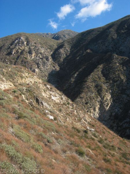
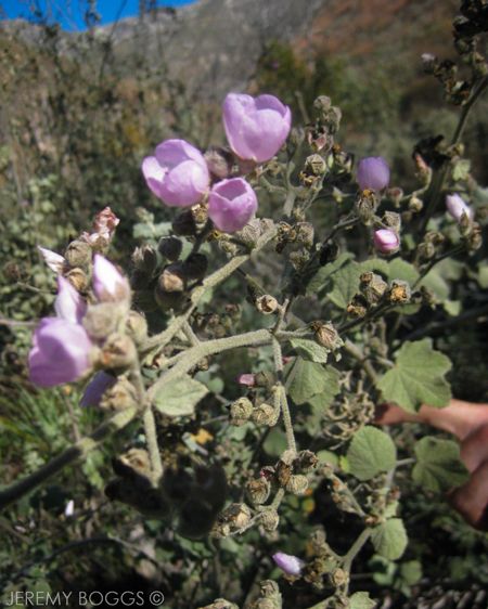
| Beautiful canyon cuts looking towards Condor Peak |

Photobucket
| Some really nice yellow & green fall color in this corridor |

Here is a major factor for those that have never traversed this trail, bc we did meet people on our exit on a 2nd attempt. Past the falls a ways someone has place orange tape up as trail markers, eventually those markers split right & switch back north east up onto a ridge that eventually leads to Condor Peak. You will know these b/c the switch backs look home-made & are un-godly steep at first. The trail to Tom Lucas camp at this point cross the creak north west, up a tributary stream for about 30 feet & then follows the west bank up the creek.

Photobucket
| Dropping down towards Trail Canyon Falls |

Back on track now our group is growing to encounter more & more poison ivy. This is not small two or three plants of the whicked stuff though, we are wading through sections that are the size of a two car garage. There is a thin path of downed foliage every once in a while to help know that others have walked here some time in the past few months. Sometime after about 2.5 miles we dubbed one area the "Poison Ivy Staircase" due to two switch backs being covered in poison ivy ascending from the banks on to a bluff.

Photobucket

About a half mile after the falls the rock cairns had become non existent. Stopping for lunch, we looked closley over the one & only map we had, plus the John Robinson description of this hike, which seemed to be from something like 1986.

Photobucket

Gathering our things, we began to set up cairns every time we dropped away from the banks & at river crossings & trail junctions. The path was pretty much up to the traveler at this point. At times we could see paths animals had made going off in other directions along the creek, but we would just forage ahead best as possible.

Photobucket
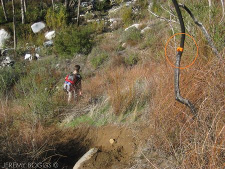
| Orange markers leading to Condor Ridge Use Trail (more details in text) |

Eventually opening up to a confluence of a couple canyons we could really look & access our goal. Standing on a large rock pile, all three of us could tell we needed to head more north east up the canyon below the unnamed peak coming off of Condor's summit. At this point our first problem is that this canyon twits & turns a lot & one can't see more than a 100 yards or so down the canyon at a time.

Photobucket
| More thick business |

We begin our best at following the loose path that it seems one other person had hiked in the past few months, there was only one rained out boot print we would see ever 1/4 mile or so. The poison ivy became less frequent, but in larger growth when it showed it's teeth. I write this 7 days later, still itching on my lower legs. Since leaving the falls up to this point we have come across only two semi-flat spots that could serve as camp if the impending growth takes over our hike too much.

Photobucket
| Point where we turned around. Notice the thick brush up canyon |

We reach a nice upper portion of the old trail that is washed out, but runs 10ft above the creek, easily better than the walking in the canyon floor. By this time we have easily crossed the creek for the 20 some odd time, dropping more cairns, & continuing up on the north east side of the river.

Photobucket

For the first time, encountering a large field of actual grass, that was over head high. Once again, opening onto a river bend with large trees turn their fall colors. With another opportunity we take a look at the  map & judge or best move. However, the waning sunlight, the unknown curves of the canyon & the general lack of trail are all slowly weighing heavier on all our shoulders. Fifteen more minutes we gave ourselves. Bushwhacking past this open field and back into the stream bed, we gained about 60 yards in that 15 minutes.

Photobucket

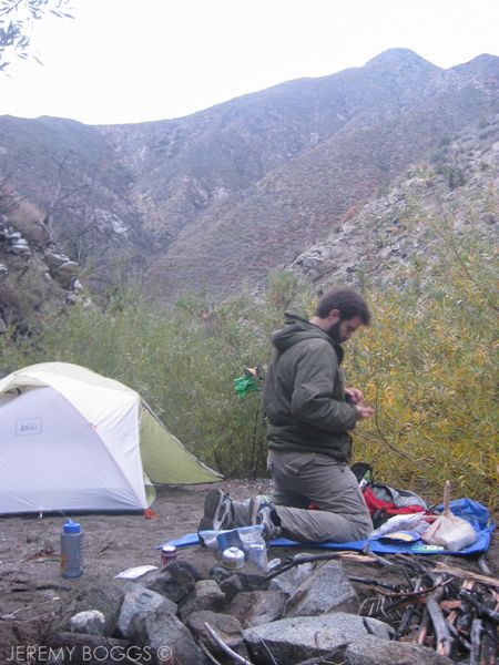
Looking up towards our goal, the canyon walls are carved in just a way so as to hide what is around the next bend. Though tough to concede, it was time to make a break for one of those flat spots we saw back down stream a ways. Collin found lots of dry grass while heading back towards camp, with a large rain storm just the previous day we needed as much dry tinder as possible. Quite possibly the saving grace for getting the evening started once we squared away some flats places next to the creek deep in Trail Canyon.

Photobucket
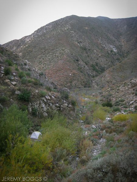
| Camp in the upper reaches of Trail Canyon |

The evening passed, the three of us well fed on chicken mac n cheese & beef stroganof (spelling). We continued reminiscing of many places we had visited this past year & the lessons we had learned walking amongst mother natures wonderful mountains. I look fondly back on two local trips in particular; one to Pleasant View Ridge as an overnight & also hiking the Three T's as an overnight trip with a fun hitch hike involved. The clouds came & went that night, at time revealing the starry nights wonderful brilliance.

Photobucket

The next morning we woke to a light mist that fell from the clouds that hung low, disguising the upper reaches of the peaks above us. Not truly certain if the clouds would burst into a down pour or hold strong for our exit, we dawned our hard shells & began our bushwhack back to organized city life.

Photobucket

Wednesday, November 14

Strawberry Meadow Backpack Trip

There are some places on a map that beckon you to explore. The graded topo lines just giving enough information for ones imagination to run wild with thoughts of the next place to uncover. Noted historian, John Robinson & climbing legend John Mendenhall's words only aided the desire to explore a guarded section of the San Gabriel Mountains.

| North Face Strawberry Peak |

Never one to appose any proposed ideas, mustache aficionado, Carlos is along for an overnight trip to Strawberry Meadow. Making final checks at Red Box, loading two days of water, cooking & all, we set off from the lot. In all the preconceived visions of this trip I had, none of them included what the first 10 minutes brought.

| Local Hunters, Info Below |

Around the bend before we even had a chance to adjust out straps comes a hunter wearing camo & a sequined teal hat. Briefly mentioning that more hunters were ahead. Not more than two minutes go buy & we cross a young man with his kill (above). He & some of his family that were bushwacking down the game trail to meet up. It was their first kill of the season & this was my first encounter with any hunters in the Gabriels. These were also the last people we saw till getting back to the car the next day.


The first portion of the trail around the lower rocky enclaves of Mt. Lawlor have be worked by a trail crew sometime over the 2012 year. Rock falls have been smoothed & filled in solid & bushes cut back. This only lasts for the first mile after the first saddle.

| Nicely maintained Strawberry Peak Trail |

While closing in on Strawberry Saddle I kept looking at the deceptive ridge route that leads up to the peak. Knowing now it's rollercoaster up & down rock scramble. Favoring not to summit any peaks on this trip, we crossed onto the north east side of Strawberry Peak, losing elevation as the saddle disappeared behind us.

| Fern Waterfall |

We knew from our previous Strawberry Peak experience that people tend to sign into the register about once or twice a month. There was not a single human foot print in the dirt anywhere on our journey. In 2009 the Station Fire ravaged this area & over the years has been recovering with nature taking over. There were deer prints throughout the entire hike, leading in all directions.

| Last views into the inner Gabriels |

The trail tends to go as follows for some time, descending the shaded recesses were over grown & head high with several types of poking & prodding bushes, leaving their itching remnants stuck all over. On the other hand, the exposed sun sections were still manageable by normal hiking standards. As we progressed more fallen trees & soft rock wash outs in certain gullies.

| Lower Strawberry Meadow |

Rounding the last ridge we get our first glimpse of Lower Strawberry Meadow. Still bringing a great smile to our face, even lacking a single living green blade of grass. The last switchbacks down to the Colby Ranch Trail/Meadow Junction are a good combination of all the bushwacking skills & solid footwork that have been building up. I assume this entire trip with a day pack would be about 40% easier.


Stepping into the meadow we can't help but marvel at the views of Strawberry Peak. It's north face, seldom seen up close by travelers. Knowing from the beginning our goal was the upper meadow Carlos & I walked on into the canyon, following a very indiscriminate trail up a wash that would be full of snow in the coming months. Using the trail up the ridge, we encountered the worst section of overgrowth on the whole trail. The last 1/4 mile is over 7ft tall of dead flora & more that one huge downed tree.

| Middle Strawberry Meadow |

Does it sound like complaining? Because I truly was having the time of my life. Finally emerging onto the Upper Strawberry Meadow we reached our destination, hidden away from the millions of city dwellers in Los Angeles.


After exploring the area before nightfall, from a distance I saw an area of rockfall that looking like a nice cave. Moving closer due to human curiosity, I started to notice many large pine cones eaten to the core, then wasit & head high branches were broken on almost all the trees in the area. Still a good 30 ft from the "cave" I decided there were too many signs of larger animals to investigate further.

| North Face Strawberry Peak At Night |

The night ended with another interesting note for Strawberry Meadow. It seemed that it's positioning receives the moonlight fairly late after the sun setting behind the ridge. The darkness that falls over the area is like no blackness I had ever experienced in the outdoors. For almost two hours if one of us turned off our headlamp, we were gone.


The morning brought promising signs of winter coming. Frost covered the meadow in a small way, but beautiful none the less. I grabbed for my new down jacket & thanked myself for spending just a bit more for this techno comfort.

| One of many tree falls |

Armed with knowledge, we dawned pants & hardshells to tackle the worst of the bushwhack in the cool morning. BEST IDEA EVER! Making our way through the meadow section, past the Colby trail Junction & up the switchbacks to the long stretch of winding trail to Strawberry Saddle. On the way up hill we encountered; tree falls, bushwhacking, wash outs, rock slides & a large swarm of what could have been bees or hornets?


The last section from Strawberry Saddle to Red Box parking lot was uneventful, but stunningly beautiful all the same. Looking back towards Mt Disappointment, San Gabriel Peak & down into the LA city basin.

| Can You See The Hiker? |

Thursday, October 18

Secret Stairs of June

So here's to a hot month with good friends dedicated to exploring our fair city. I know this post comes late, but it combines two different outings into one, so the reader has more photos to enjoy.
 

 If there is one thing ingrained into my mind about this walk months later is... "sweating". One time prior we attempted this loop & took a wrong turn, never completing our true objective. This time we were determined to have success.


With careful navigation we made it up to the numerous steps & onto the upper reaches of this thin mountain neighborhood.


 Curving slowly back down, we made sure to double check at each switchback turn to come out with a full work out on this trip.


The second adventure was an old walk with an old friend, for the first time. My friend Keith drove up from San Diego to take some photos & catch up on life.


We dove into the Alta Loma Terrace walk b/c it truly is one of the top five in the book. This was the fourth time walking the long shaded corridors & marveling at the 1930s elevator that accesses the neighborhood. This time was different b/c someone had photocopied & blown up the walk we were on!! (photo above)


After the standard walk we ventured across the street & circled Whitely Terrace for a bit more exploring. This was a really unique neighborhood with steep staircases. The photo below is looking at Alta Loma Terrace from Whitely Terrace. One of the more beautiful views in the cluster of Hollywood.


Wednesday, October 10

Three T's Backpacking Trip - San Gabriel Mts


Pulling up to the Icehouse Canyon parking lot, we could tell we were late for class... Packed to the brim & beyond with cars. Not uncommon though, especially if you've ever been to Chantry on the weekend. Hoisting our packs, we did some road walking to get to the trailhead & set off in high spirits towards Icehouse Saddle. Our goal for this "boys" trip was to try a new trail (to us) that qualified as a more strenuous hike, as well as call our own shots for where to camp, a bit more "thru-hiking" style. The Three T's Trail will take us to three different mountain peaks that all begin with the letter T... and they all require to go down before up.

| Hiking up Icehouse Canyon |

Heading up Icehouse is such a picturesque canyon at times (other times over used), dotted with cabins from the 1920s along the first couple miles. The name derives from early Los Angelenos using the canyon to produce ice, the positioning allows for the snow to last long in this area. After a couple miles & a 1,000 feet up, we came to Columbine Spring, flowing straight out of the mountain, this was out time to fill up b/c there would be no water till tomorrow when we finished our hike. We were only 2 miles in to 10 miles our trip was looking to be. Hoisting our packs once again, the weight of roughly 6 liters was very apparent.


The spring is also conveniently located at the beginning of the steepest part of the trail. So, up & up we went, covering 2,260 ft of elevation gain, to the saddle (3.6 miles). Affording a nice break & a chat with many different hikers that always tend to congregate at Icehouse Saddle (if we were still using the high school analogy from the beginning, the saddle = the cool kids lunch spot). Lots of people wanted to know where were going & would follow with, "are you staying our here tonight?!"

| Looking down Icehouse Canyon |

Collecting our things, hoisting our packs & getting a traditional trail group photo, we moved on towards our first peak, Timber Mountain. The crowds thinned out as we headed along the sides, switch-backing up, slowly gain grander views of the canyon we just hike through. Topping out on a western flank of Timber, we spotted a spur trail that was a half mile round trip to the summit. Dropping our packs, Collin man-ed up & carried his in case of good camping, we climbed to the summit of Timber Mt.

| Carlos on Timber Summit - 8,303ft |

Getting a chance to scout tomorrow's route & also evaluating if we should press on to find camp or stay on the flank near the spur trail junction. Opting to stay put & camp on the rounded flank of Timber Mt, sort of near the spur trail junction.

| Camping looking out towards Telegraph Wash |

This post seems to be getting lengthy already and the sun hasn't even set on the first day... I would say the photographs & the video will do the evening justice. The views were spectacular all around, there was nice shelter from the wind & a beautiful morning to wake up to the next day. 


Packed our gear, took some photos, ate a hearty breakfast & we were off towards our next peak. The trail down to the saddle after Timber was easy as could be without a single other person in sight. However, we were constantly reminded of the test that lay before us, the trail continuing up to Telegraph Peak.

| Collin & Carlos looking to the West |
Beginning a bit tough & through some overgrown shrubs, the trail climbs quick, slowly becoming a better graded adventure after a mile or so. Part way through our uphill climb I wished I had began to count to switchbacks going up this darn mountain! Alas, I didnt even heed my own advice b/c if I had begun counting even half way through the trip it still would have amounted to over 20 I imagine, only part way up... maybe closer to 35 total? Below is a picture of the task ahead, Telegraph Peak being the furthest in the back right.

 
| Telegraph Peak, back right |

The wind was a constant companion that breathed new life into us as we snaked up the mountain, popping out at time to get craggy views of Telegraph Wash. Finding another spur trail with a round trip of a half mile to the actual peak... the standard ensued, drop packs & hustle to bag another peak. Quite easily one of the best summits I have stood on in the San Gabriels. One could count more than ten peaks in the area that are all glowing in monumental triumph. Before leaving our roost on Telegraph, we scouted our route to the next peak, opting to try & climb straight from the next saddle up to Thunder Peak. Normally the trail takes a nice loop around the whole summit & doesnt actually touch the peak.

| Looking towards Bighhorn Peak & Coucamonga Peak. Do you see Collin? |

Signing into the Telegraph Peak register, we hustled back, hoisted our packs & set off down hill towards the next peak, with two in the bag. At this point we crossed our first people since the day before, coming from the Baldy Lodge direction. This portion of the trail is really well graded and a nice hike in either direction. 

 
| On Telegraph Peak - Lt to Rt: West Baldy, San Antonio Mt, Mt Harwood, Pine Mt |

Arriving at the saddle, Telegraph Peak looked to be a behemoth of a summit from here, but nothing compared to the way we came from. The wind howled in the confluence of the canyon, cooling all of us to the core. 

| Mt. Baldy early morning |

Sticking to the off trail climb, we made our way slowly, designing our own switch back pattern up the backside of Timber Mountain. After a few good rests & some steep walking, we arrived at the ski boundary 50 yards shy of the summit we were aiming for. A good timed photo of Collin, Carlos, and I bagging our third peak for the trip!

| Hiking up to Telegraph from Timber Mt |

We have now crossed into the Baldy region of the San Gabriels. In the winter it becomes a ski resort & our goal was to walk the dry ski runs down to the lodge that operates on the weekend for hikers. Doesn't sound too challenging right? Well, not the case. Day hiking isn't too bad, but after two days, three summits & over-night gear on your back, the rock strew wide open gulleys are a twisted ankle waiting to happen every step. With toes cramping from the downhill we strolled into the Baldy Lodge ready for a burger & a beer.

| Down the rock strew ski runs w/ Baldy Lodge in sight |

After feasting, we had two more goals, to take the chair lift down to the parking lot & somehow avoid the many miles of road walking we had to do to get back to our car at the Icehouse Canyon trail head. Fortunately there were many others finishing their day hikes & heading back down the mountain, after a friendly chat with a young newly wed couple, I cracked the question to see if they could take 3 smelly guys down to our car? They were much obliged & we learned they were new to hiking in general & had managed to get a coupon to the "ski lift & lunch" that took them to some of the best views they'd seen! Great times all around in the outdoors.


Is this the last backpacking trip of the year?!?! It's getting kind of chilly.... we'll see.

Sunday, September 23

Pleasant View Ridge - Backpacking San Gabriel's


Not quite everyone knows about Pleasant View Ridge in the San Gabriels mountains. Heck, it took me some reading before I knew there was even a little know trail that wandered along the ridge top like a roller coaster with no handle bars. With no water in site & views for miles, this was a battle worth it's weight in nature's gold.

We opted for the longer route, starting at an earlier dirt turn out along HWY 2, not going the standard route from Islip Saddle. Putting on 19 pds of gear is no problem, then adding 11 lbs of water is a bit trickier. From step number one it was all uphill. Heading south on the PCT was easy going. Up sharply cut switchbacks on the backside of the craggy ridge that forms the only tunnels on the Angeles Crest Highway. Passing right below stunning rock formations looking out into Bear Creek Canyon.

Topping out on the PCT, there is a white arrow to direct those that are making the 2,000+ mile walk from Mexico to Canada. However, this is where Carlos & I tread off the main trail, making our way onto Pleasant View Ridge, towards Mt. Williamson. Without too much verbose detail the next couple miles of the trail is a true wonder. This are of the mountains receives far less traffic than many others. And the few people we did see where very kind & very serious about their love for the outdoors.


After a series of up and down hill struggles along the ridge, one of them easily being the steepest I have traversed down hill, while still being on some semblance of a trail, knowing very well the next morning we will be walking back up it......... the good kind of curses came out. For real adventure seekers, there is wreckage from a plane crash on one of the hillside we spotted (photo above). The video below has some great footage of this section of trail.

That eve we picked a wonderful spot along the ridge top, literally on a rounded ridge with barely enough flat area for our tent. I'll let the rest of the story be told in the video... enjoy.

| Click to Play |