| SECTION 1 - Will Rogers State Park to Kanan Road |
There are those cliche sayings like, "...adventure is just around the corner." and "There is a great big world out in your own backyard." Welp! This trip proved these to be cliches for a reason, a big adventure was right outside our back door.
There's always talk of the 'next trip' amongst any friends. First looking at Sespe River as a thru hike option, but as logistics & dates were discussed there were some small road blocks that put that on the back burner for another time. Then the idea to hike the whole Santa Monica Mountain Backbone Trail was thrown out there. We had all see the trail signs while day hiking locally, but the idea of a new approach was enticing.
Deciding to hike the entire 67 miles in two weekends was our best approach to allow for work & other obligations to stay on track. There are some logistical issues to this trail that are different than others, namely camping locations & water sources. Check with the NPS at Santa Monica Mts for more info on those things. We set up water caches a day prior at road crossings to help us move without fear of going dry, which would definitely have happened had we depended on the only 5ish natural sources we saw.
We set off from Will Rogers before dawn in March, hiking the trail in a Westerly direction, purely because we wanted to end, hiking downhill to the beach, as opposed to ending in the city at a public park, blah! This proved to be an outstanding reward & gave us an unsuspected challenge, but more on that later.
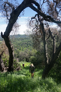
The first eleven or twelve miles was really nice hiking, views all the way to downtown Los Angeles one direction & all the way to the Pacific Ocean the other. The very early Spring weather brought hundreds of birds out.
We reached Topanga State park as the mornings day hike crowds were just starting. We came to a crossroads where the traditional route goes below Eagle Rock, while you could go up & around to stand on top of Eagle Rock. Traditional route from this point on was our goal.
Heading down the Musch Trail into the park proper was outstanding! A barreling canopy of green ivy proved great shade as the day grew warmer. Counting seven different species of wildflowers along the side of the well worth path only added to the small surprises.
After brunch we set out across a couple roads in Topanga Canyon & one of the more tricky navigational portions. At one point before you reach Topanga Canyon Hwy the trail drops down to the backside of an elementary school playground (it looked like). Then you wonder if you made a wrong turn... hang a sharp right (north) & walk up a paved short road to two huge white water towers. You'll see the path begin on the right side of the towers, then drop down to a really nice green area, eventually to the highway.
We had looked forward to crossing into the local Topanga interpretive trail, only a half mile or so, but really informative. Wonderfully hand painted signs educated on plant biology & local history. The only random part, was this section of the trail was exceptionally steep. Funny for something I'd normally assume to be leisurely as an interpretive trail.
After Old Topanga Road we filled up on water & headed up into Hondo Canyon during the warmest part of the day. Despite looking at a pretty decent climb, this portion would eventually land in my "Top 3" favorite sections by the end of the trail, but also agreed to be the hardest climb b/c we hit it at the warmest part of the day.
The rolling meadows of grassy fields & oak trees gave way to large sandstone cliff bands a thousand feet above. We wandered throw bright yellow meadows of shoulder high wild mustard & wild purple lupine. It was some of the best Los Angeles hiking I had done. Absolutely outstanding. The curving trail lead deeper into the rugged canyon that had very different features than many of the other reaches of the Santa Monica's.
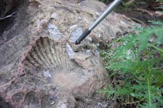
We'd been hiking about seven hours now & found a large rock to split the climb in half, taking a rest in the canyon shade. Topping out of Hondo Canyon felt great, with a bit more climbing along Fossil Ridge to go. Only adding the the magic that was the afternoon in Hondo Canyon, we were treating to ocean views all along the trail across the top of Fossil Ridge. The icing on the cake was the large fist size shell fossil imprints left in many of the rocks right along the trail.
Reaching the Stunt Road junction we sat on a bench & took in the views. Another nice benefit to this thru hike is these small respites of road/trail heads with trash cans & sometimes bathrooms to help alleviate carrying too much nonsense.
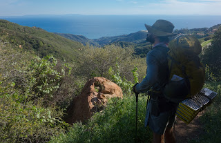
Moving on we had to walk about a hundred yards down the paved road to where the trail continues, uphill. This was the only wrong turn we made, or lack of making a turn, we continued on the main trail towards some antennas. Realizing our error by taking out the map, it was only about a fifteen minute mistake. It also awarded us with some of the best ocean views yet, clear as could be all the way to Catalina Island.
Now heading the right way, the trail dropped down right through some impressive rock towers revealing views far across the valleys to Los Padres National Park. For miles & miles we head downhill, hitting some steep switchbacks & sneaking looks at the next section of the Backbone. We were learning the name of the game now... miles of roller coaster ups & downs along the spine of the mountains, then drop into a connecting canyon, only to climb back up to next portion of the ridge line.
Reaching Las Virgenes we ate under the bridge & refilled on water. Being quite warm & sunny we hit another heavy duty climb on open fire roads. Super hot, super sweaty, we hugged the inside portion of the trail to stay in the small shaded sections. Once on top, again, the ocean views were all the reward I needed to forget about the previous hour of grunting.
More than ever, the fire road climbed up only to drop down, eventually reaching the Medicine Rocks area. The route traces right along the true spine of the mountains, with sandstone formations that look like a Stegosaurus' back! The trail then winds down below Castro Peak (I think due to private land) into a wonderful canyon area. The trail did seem to take a while to get anywhere at this point, but it was beautiful.
Climbing to the last saddle of the first section on Sunday evening, we hiked trail that goes over the Kanan Tunnels & dropped our gear at the Kanan trailhead parking lot. Just a hint under 40 miles from our start at Will Rogers State Park.
Then we got some beer...
| SECTION 2 - Kanan Road to Point Mugu State Park |
Time had passed, as it does, but only by three months. We decided to jump on an open weekend & finish up the second & last section of our Santa Monica Backbone trip. Starting again before dawn where we left off at Kanan Rd, we had completely different weather this time. June gloom near the beach was in full effect with a thick marine layer covered the hillsides.
We walked on through the enchanted lower canyons, the oaks gnarled & twisted gave a magical feel that added to the beauty. There was a dense green to all the flora around from the heavy moisture. The trail connected us over and through several great canyons before long we had covered a good distance.
After some more standard uphill we crossed a road & began climbing up into the Encinal Canyon area. The trail had become noticeable less steep & well graded, it was mountain biker heaven for the next seven miles of trail. Not one yielded to hikers like the ethics call for, but maybe next time.
Still stuck in the clouds along the upper reaches we hadn't seen beyond 100 yards all day. Though refreshing & a bit humid compared to our last time in the mountains, I was really missing the views. But patience would prove to reward us.
We rounded a bend & the clouds finally parted after seven hours of hiking. We could see Sandstone Peak, the highest point of the Santa Monica Mountains & our next climb. Pausing for a good rest at the Misha Mockwa trail head before we snacked & gathered our last water cache for the trip. The next 15+ miles had no dependable water sources.
After much sweating, the summit of Sandstone Peak was a crown fit for the Santa Monica Mountains. All around the views were dynamic & ever changing. The Pacific Ocean, thousands of feet below one way, large rolling chaparral meadows punctuated with massive sandstone monoliths to the other. Snapping a quick group photo we headed on. From this point on the crowds thinned out considerably... more like we didn't see anyone for miles & miles.
Merging onto the Chamberlin Trail we navigated through more amazing sandstone windows that would offer views to the sprawling sea of clouds that covered the ocean below us. It had been really nice to hike above the clouds, but we were losing elevation & heading back down into another canyon. Not without one last memory searing vision of the tall sandstone cliffs guarding the deep reaches of the Santa Monica Mountains.
Another a couple hours of downhill hiking we emerged below the clouds in the Boney Mountains area on the edge of the 2013 Springs Fire. None of our group had hiked any of this area so it was real treat to see something new.
The fire had really ravage the area, all corners in all directions the mountain sides were burned. Outstanding flat & fun trail took us along the bottom of Big Sycamore Canyon to Danielson Camp. A great rest stop with bathrooms & a huge group camping area. There is a private residence on the property that a family uses from time to time a local told us. Many mountain bikers passed through the camp looking for water & it seemed to have been shut off at all the outlets. They said this was odd & there was almost always water at the camp. Glad we didn't rely on that info.
Taking the traditional route down the dirt road we came to a shaded picnic table with the junction that will take us back up to the Backbone for the last time on the trip. Just across the from the trail junction there was a running faucet. It being the hottest part of the day & the clouds gone, we dosed our clothes in water & headed up hill, fully exposed to the sun in the burn area.
Although the heat didn't bother me like I though it would, the views melted away any pain that I felt. The trail we were on was breath taking! We would see the whole canyon we had hiked down, then on up the switchbacks to the saddle that leaves the Sandstone area. Truly a wonderful feeling seeing all the ground we had covered.
After more mountain bikers not yielding to hikers, we made it to the fire road that would take us along the last spine of the mountains towards the ocean. Some might say hiking a fire road can be boring, but this one had views all around us that kept all my attention. La Jolla Canyon looked huge from far above & is now a place I need to explore soon.
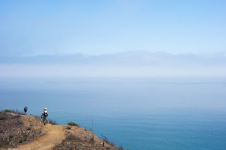
We came to the last junction, turned right on the Ray Miller Trail & reaped three absolutely gorgeous miles of downhill hiking. It is hard to describe how it felt to come from the far reaching canyons & hike down this ocean front trail straight down to the ocean. A permanent smile never ceased while the crisp ocean gusts blew my hair back. I couldn't get enough. I was so glad we had chosen to hike the whole trail in the direction to end here.
At the bottom we crossed Pacific Coast Highway, dropped our packs in the sand & took a dip in the Pacific Ocean. What a magnificent hike. Our last goal was to get to our car that was parked about 5 miles south on PCH where overnight parking is allowed. After a friendly conversation with a family of hikers we snagged a ride in the bed of their truck down the highway.
INFORMATION
Total: 67 miles. 18,497 feet climbed, 18,232 feet descended
The four Tom Harris maps were extremely useful.
Very helpful trail running report: HERE
Andy King has a helpful website: HERE
Not too helpful, but fun, Backpacker article: HERE
The water caches put in place were removed as we hiked & were created with leaf foliage that surrounded the immediate area. No impact was left.


