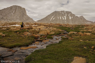
| Piute Pass center back |
Californians have it good. Without question. The weather, the land, the access to adventure is endless. Don't get me wrong, every state has it's amazing beauty, but the Range of Light, the Big Sur coast, the crags in Death Valley & up to the dense old growth forests of NorCal... seriously all here to explore. Let's see what's beyond the trail.
For sometime now I wanted to take my backpacking skills to the next level & plan a short multi-day trip that would take some confident friends off trail to unique places in the Sierra we had only looked at before. Spending a few weeks of research, I had put together a combo of options that untimely led us to a fine little route above & below treeline for a few days.
Parking at the North Lake Piute Pass trailhead we had a solid group that would slowly diminish over the following days due to city obligations. Ultimately three would be left to finish out the last days.
| Rough outline of what we did |
Off we all went up to the first pass on trail. Gorgeous, steady & never truly grueling we all topped out with earned insane views into Humphrey's Basin by mid afternoon. The trail took us down to an exposed but sizable horse camp below the pass.
| Over the pass |
| Part of Humphrey's Basin |
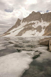
The next morning two friends had to get back to the city so they hopped back over Piute Pass while the rest of us set out to find Desolation Lake. Missing the obvious spur trail that everyone else seemed to write about was not really a problem, we just wandered around upstream till be found the outlet leading the right way. Another hour of hiking brought us to the massive & barren Desolation Lake.
| Lower Desolation Lake |
At this point two more members were going to spend the night here & then take two days heading back out the way we entered the Sierra. Gorgeous & expansive were the surrounds while we all snacked together.
| Glacier Divide |
| Mt. Humphrey - 13,151ft |
The last three of us that were to continue on were eyeballing Puppet Pass/Carol Col in the distance that seemed to be holding some snow in places. It was early September & last winters snow still held in places. Roper & Secor have great descriptions of this area & are pretty spot on for approach ideas. Another extremely valuable resource is High Sierra Topix.
| Puppet Pass. Just on the right shoulder |
| Down Puppet Pass - Roget, Blanc & Lorraine Lake |
We picked our way through the inclined slabs that make up much of the Sierra above tree line. With a keen eye these natural ramps can take a hiker almost anywhere they want in the mountains here. Topping out we strolled to the shoulder of an unnamed granite spire on the cusp of our next massive basin. Hunting across the top of the off trail pass we never did find the plaque that commemorate someone named Carol that unfortunately passed away up here, but we did find the jump off point to scramble down into the basin. Never too difficult with care, this was perfect class three terrain between 11 & 12 thousand feet.
| Pilot Knob - 12,245ft |
| Looking at French Canyon, Pine Creek Pass & beyond |
| Moon Lake. Merrian & Royce Peak in distance |
Views stretched for miles & miles in all directions. We could see across French Canyon to the Royce Lakes area we were aiming for tomorrow morning. An absolutely massive waterfall was spilling over the cliffs that only amplified the beauty. Still hiking off trail we picked our way through snow fields, passed cliff bands & down to Moon Lake. This was our original goal for camp, but it was still only two in the afternoon. After a decent rest we shouldered our packs & set off to find the main trail down in French Canyon.
| Four Gables Sunset |
Back lower in the trees & on trail, we put a little dent into the morning's miles before resting. After browsing the possible camp sites all along the trail in the canyon, we settled on a knoll overlooking much of the upper peaks. A small rain patch blew over, but didn't soak us much.
| Alpine - Merrian & Royce Peak |
The next morning we had trail uphill for an hour or so up until we reached the tarn at Pine Creek Pass. From here we set off for the next off trail section up towards the alpine environs. Without much trouble a steady climb was had away from the pass & along perfect green tundra. Giving way to a moonscape of stunning beauty.
Taking shelter behind whatever boulders were the largest, we admired the grandeur of it all. Merrian & Royce Peak (13,253ft) right above us. Pushing further towards lake 11,725 a large boulder scramble ensued along the southern shore. It wasn't terribly hard, just careful movements.
| Kevin with Feather Peak |
| Lake 11,725 |
Our objective was to round the entire lake & use Granite Park Pass to move into the next drainage. More boulders, boulders, boulders. Then a disheartening sight. Quite a bit of snow was still hanging around in the path of our approach. Kevin even gave it a good look from above, seen in a photo below. We sat for a snack & talked options. Without foot traction devices or snow tools it would be sketchy at best, without knowing what the decent looks like as well.
| Other side Lake 11,725 |
| Granite Park Pass left of center with snow in gully.
Kevin is tiny in the very upper right checking out
the rest of the snow & angle (click to enlarge). On the other
side is a thousand foot descent that we can't see too. |
Kevin is tiny in the very upper right checking out
the rest of the snow & angle (click to enlarge). On the other
side is a thousand foot descent that we can't see too. |
We opted to back track thirty minutes or so & access Royce Pass. This would take us down into a different canyon, but ultimately leading in the direction we needed to go the next day. Though maybe not the technical thrill that Granite Park was going to be, Royce Pass made up for in sheer beauty. An easy hike off trail down waterfall laden shelves of granite were ideal after all the large boulder tramping above.
| Royce Pass looking into Pine Creek |
| Looking back up at Royce Pass |
After an hour or so of this terrain. we veered off to find Golden Lake for our last night out in the Eastern Sierra. We all grabbed a super gold dip into the lake & enjoyed whiskey topped off with a golden sunset garnish.
| Golden Lake |
Packing our bags for the last morning, a 3,000 foot decent into Pink Creek was needed to find the car. We spent about a hour off trail in the trees & along the slabs, eventually crossing the main trail down the canyon. Cruising now, lake after lake passed by with views to the high places we had been days before.
| Honeymoon Lake. Royce Pass left of center |
Knowing now, Pine Creek would be a tough hike uphill, but down was a steady push with cool sights. Larges cascades at times roared just below. Opening up to beautifully blasted switchbacks lower down. Also treated my historical nerd side seeing an early 1900's era mining operation. Crazy to envision the multi-tiered ore tunnels dug high on these cliffs at the Brownstone Mine.
| Look close, multi-tiered shafts |
Landing finally in the dirt parking lot at the Pine Creek trailhead we all felt really great about our first off trail romp in the Sierra. Till next summer season, the maps will be out & helping envision future wonderful trip outdoors.


